AVL Mapping / Mobile Solutions
Relativity, Inc.’s Mobile Suite provides officers with maximum mobility … allowing them to spend more time out in the field, focusing on their primary task of protecting their communities.
Automatic Vehicle Location System (AVL)
The AVL system provides your dispatchers with a view of every patrol car within your dispatching area. This is a valuable tool that has saved lives by providing officer locations when they are unable to communicate with dispatchers. The AVL mapping allows dispatchers to assist officers when they are having trouble finding an incident location, and has even proved useful to protect officers when falsely accused of certain actions. The AVL system provides dispatchers with the ability to view patrol car speeds, status, whether or not their lights are on, and other valuable information. The information collected can also be viewed and played back historically, in case activity from a previous day needs to be reviewed.
Relativity Mobile Data (RMD)
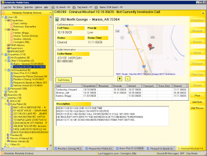
rmd is an intuitive system that allows officers to receive dispatch call information seconds after it is captured by the dispatcher while out in their patrol car. Officers can also run NCIC checks and chat with dispatchers and other officers, reducing radio usage for routine activities. rmd is designed so the officer has strong situational awareness for the calls assigned to their unit, as well as other active calls. One of our favorite quotes relative to rmd was when an officer told us “I can’t imagine doing my job without rmd.” The rmd solution uses the FBI-CJIS dual authentication protocol to ensure secure communications.
Relativity Mobile Incident (Mobile O/I)
The Mobile OI system allows officers to enter their NIBRS compliant offense reports while out in patrol vehicles, increasing their time out on the streets. Officers can receive report approvals / disapprovals during their shift and make the corrections needed immediately, so that cases can be quickly transferred to CID.
Relativity Crime, Warrant, Dispatch Activity and Sex Offender Mapping
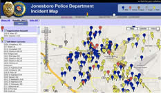
Relativity’s geo solutions offers your agency the ability to visually monitor incident information, sex offender registrants, and warrant information.

Incident and Activity Mapping is crucial for effectively identifying crime trends and target areas. Our mapping solutions provides your agency this information with just a few clicks of the button.
Additionally, our mapping solutions provide your agency with the opportunity to share information with your community. Citizens can view important information about crime activity and view where registered sex offenders are living in the community. Providing this information helps the citizen-stakeholders by providing them an easy way to see where crimes are occurring.
Relativity’s mapping solutions are web based and easy to navigate. Our map is seamlessly integrated with our other rps products to provide your organization with a full circle solution.
Fleet Tracking
Relativity offers fleet tracking applications for fleets of any size. For the organization needing to track a smaller number of assets, we offer a SaaS (Software as a Service) on a monthly fee based model that will allow you to track your vehicles without having to make an infrastructure investment. For larger organizations, we provide a blended model of both locally installed and browser based viewing capabilities.
Team Relativity provides total solution turn-key AVL installations and system management for our clients. For more information about our Mobile solutions, contact Relativity sales at 870.802.3622 or info@myrps.com.

